December school runs through the woods – weaving our way between the holly that throngs around the oaks and under the ivy that clambers up the sycamores – are a countdown to Christmas. We grasped the opportunity for another early morning cloud inversion before school, the valley filled from Todmorden to Halifax with a writhing glacier, blue at the shadowed headwaters, glowing gold downstream where dawn had reached by the time we had to plunge down for the bell.

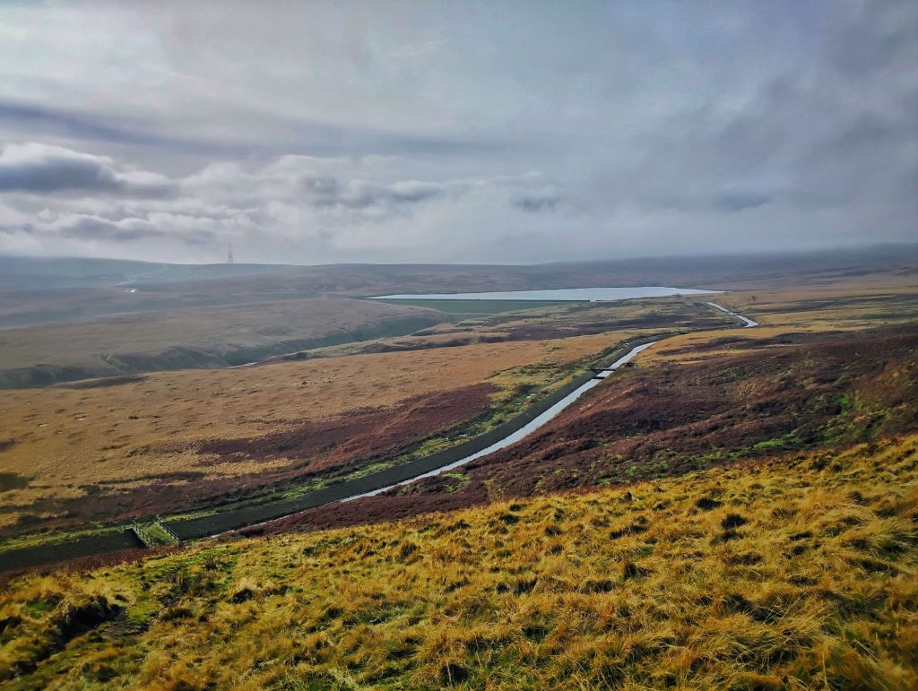
The day after, I spent a few hours exploring Rishworth Moor in the beginnings of a joint project with photographer Clive Horsman. From the stone span of Oxgrains Old Bridge we followed a stream between the ramparts of Castle Dean Rocks to the slate expanse of Green Withens Reservoir, then accompanied its northern catchwater drain until striking off up to the trig point on Dog Hill. For all the hazed greyness of the day, and for all that the images Clive captured will stunningly reveal the form and essence of the place on black and white film, there were colours to appreciate: the terracotta of dead bracken, the pastel green whorls of next year’s foxgloves, the fawn of moorland grasses, the deep lime of bilberry stems, the ochre of iron oxide deposits leaching out of the exposed streamside shales. At our backs, the Windy Hill transmitter solidified out of the mist and the M62 roared, then quietened a little as the torrent of the eastbound lane was dammed somewhere over the Greater Manchester border. We stopped at several points on the spillway, dam wall and catchwater filters to admire the Wakefield Water Board’s 1898 construction aesthetic, combining overengineered functionality and an unnecessary elegance in a way only the Victorians knew how. We found curiosities and treasures along the way: clusters of bog pondweed in the otherwise sterile culvert of the catchwater; a startled snipe among the heather; signs of amphibian demise in globules of star jelly spilled on the turf; wrens flitting among the stones of old sheepfolds; an unaccountably remote instance of fly-tipping high on Dog Hill, of a Little Tikes playhouse; recent but mysterious pockmarks across the face of the moor; the spoor of Whinny Nick, a pre-reservoir track to seemingly nowhere. Everywhere, even the most unpromisingly blank territory, is seamed with stories.
On the evening of Friday 13th, the A646, the main road through the Calder Valley, was closed to traffic at Charlestown. Ground penetrating radar had revealed substantial voids, into which the road had been sinking for months, with repeated laminations of tarmac serving only to save people’s suspensions until the next collapse. Over two weeks later, as of the end of the year, it remains closed. There can be few places in the country where the consequences of such a decision could be more complex and severe, with chaos caused by the lengthy diversions on narrow roads through hillside villages and hamlets, and the consequent impact on local businesses in loss of trade. Knowing that this had happened in 1972 at the exact same spot, my son and I went straight to the library to search through the contemporary articles in the Hebden Bridge Times on the microfiche reader. Our findings about the mill goit deep under the culvert and sewer that is being repaired this time are written up on another page, ‘The Charlestown Hole, 1972’. We made daily visits to see the excavations deepen, and the Trenchless Solutions workers and the Yorkshire Water project manager were very friendly in explaining each time what they were finding, as well as extolling to my son the virtues of a career in engineering. The cat’s cradle of water and gas mains, internet and electricity cables, the sewer pipe and the stream culvert that they were having to work around was truly intimidating, as was the depth of the sewer manhole they allowed us to (safely) peer down. On Christmas Eve, we took them down a bag of Heroes as a thanks. Being a car-free household, and also having no essential business in Todmorden (unlike many in supermarket-free Hebden, who do their weekly shop there), the road closure thankfully had no practical impact on our lives. Its most significant effect for us was a positive: a still silent valley. Over 10,000 vehicles pass through every day, and only during lockdown and flooding has the noise of it ever ceased during the daytime. While acknowledging the hardships it is imposing on so many, we are savouring every day of this brief respite being able to hear the natural sounds of a hushed valley – the cascades in Beaumont Clough, the whistle of a dipper down on the River Calder, the plaintive song of a mistle thrush in Horsehold Wood – as well as being able to walk along the narrow stretches of pavement towards town without the intimidating roar of HGVs bearing down from behind. Indeed, close to the hole within the barriers, I allowed him, and the succession of friends that we took down to visit, to dance and cavort in the middle of the road for the sheer pleasure and novelty of it. On two school runs, we went to see a cause and an effect related to the closure. An effect, which we took in one morning after climbing to see the latest dawn, was the spectacle of an enormous flatbed lorry stuck on Mytholm Steeps being rescued. Having passed the ‘No HGV’ signs and negotiated the first hairpin bend, the second proved impossible, so one of the few diversion routes was blocked for the night, until a recovery lorry with a winch came to lift its rear end around the remaining bends. And one evening after school we went to find the cause: the stream which has been leaking out of the culvert and creating the voids under the road. We ascended into the high pastures to its source in the deep rushes, then followed its half-mile course on its 575-foot tumble down the hillside, through quarry and coppice, grasping bramble and dark scratching holly, until we slithered down the terraced remains of the demolished slum of Old Charlestown, out of the benighted woods and into the blaze of floodlights at the works. It is something we have done before in the other direction, and it struck me this time as it struck me then, that given how impactful this secretive little unnamed watercourse is on the life of the valley, flooding as it has the main road and the unfortunate nearby terrace many times over the years, and now causing the severing of the valley in two for weeks on end, it is remarkable how little attention is paid to the source of the problem.

On our way home from the library on the first full day of the road closure, we climbed over Horsehold Scout for a view of, and a listen to, the valley. We could see many cars learning of the closure for the first time as they encountered the signs at the Heptonstall turning circle, and could imagine the curses and rapid recalculations of routes and plans going on inside each one. At the listed arch of 18th-century Beaumont Clough Bridge, we surveyed the ravaged streamsides, with an uprooted birch discarded on the bank, victim of the combined snowmelt and rainstorm three weeks ago. We could even see the effects of runoff from the Edge End meadows in the way the grass was matted in one direction in the sunken track of the ancient Halifax–Rochdale road. Up at the farm, the barn door was open and some of the cattle herd were at the entrance, seeming to be contemplating whether it was time to make their way inside for the winter. At Cruttonstall, as we were marvelling at how we could smell the wind-borne smoke from a fire at one-and-a-half-mile distant Rodwell Head, we noticed people approaching the ruin from the top of Callis Wood. In all the many, many times we have been to this spot over the years, the only people we have ever encountered are the farmers. It turned out that they, and the stream of other small groups and pairs that hoved over the horizon in their wake, all wearing Santa hats no less, were participants in ‘Moors the Merrier’, a 21-mile event organised by CraggRunner. As well as the Santa hat, they each carried a present for the bran tub lucky dip back at the Hebden Bridge Golf Club finish. After we watched one poor runner come a cropper in the bog on the other side of the gate, my son established a service, rather like Gollum did for Frodo and Sam in the Dead Marshes but with better intentions, of leading people through, showing them exactly which rushes to step on to avoid a trainer-full.
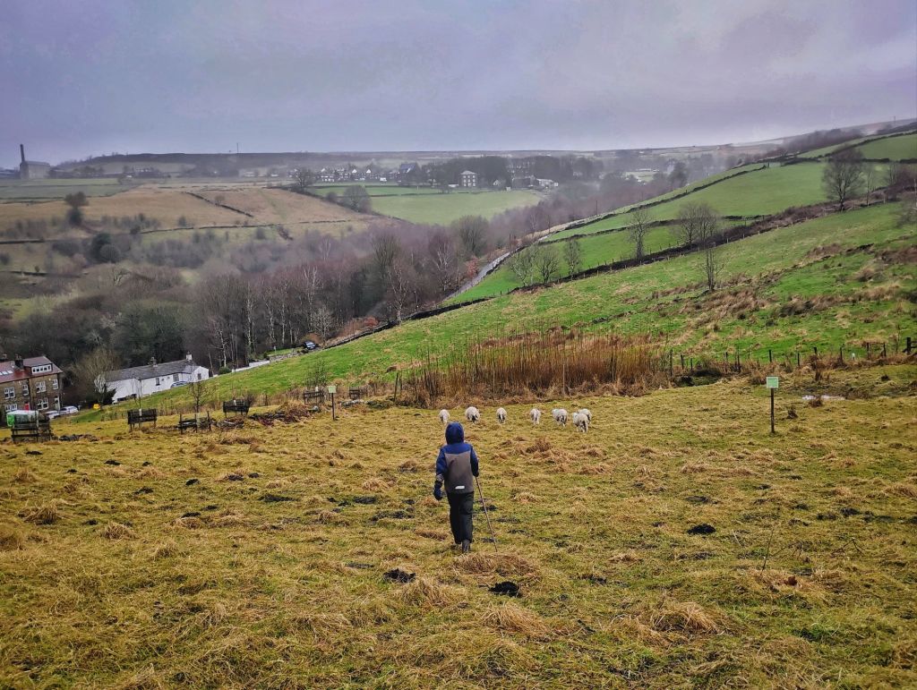
Our Sheepwatch duties continued at High Hirst. Although the hazel coppice was now free of leaves, at least one member of the flock still somehow contrived to remain hidden until we had started to seriously contemplate the possibility that either Ed had been to take one away or else we would have to report some rustling. Our turn just before Christmas, when we had carols about shepherds watching their flocks in our heads, was in wild weather, during which we were blasted with a flurry of snow, which then cleared to reveal a faint rainbow, and as we herded the flock up the slope, we briefly had a star to follow. After Christmas, the flock had been moved into to neighbouring Law Field. Fenced by volunteers last summer, it is a considerably different terrain, with tussocks and bogs making clear the work that has gone on, gifted to us by our predecessors, to make a meadow possible to scythe; there is no doubt that to try to mow the pasture of Law Field would result in bent and blunted blades and demoralised mowers.
On Christmas Eve, after It’s a Wonderful Life at the Picture House, we positioned ourselves at the turning circle with friends for the charity Tractor Run, growing every year and now involving over 200 tractors, trucks, diggers and other assorted land-based industry vehicles, all bedecked in tinsel, fairy lights and Christmas trees, horns blaring, music playing, drivers waving. We chatted about how the Old Chamber sheep were faring to Ann, who was rattling a bucket for Forget Me Not Children’s Hospice, for whom the event raised many thousands of pounds. After a Christmas Day spent, of course, largely inside, apart from a pre-dinner saunter with friends around our local loop and a drink at the Stubbing Wharf, we visited Ann for the Boxing Day Butty Box, where she and Sal served us delicious hot food and hot chocolate. The great tits ‘teacher, teachering’ in the woods of the silent valley made it sound almost like spring, but as we climbed the low grey cloud thickened until we could barely see into the fields on either side of the lanes. We could just about make out Jacob setting mole traps in his meadows, and the baler at Erringden Grange left where it had disgorged its final bale of the summer, and rooks cawing from the wires and jackdaws feeding among the sheep. A horse and rider suddenly loomed black out of the fog, but a honking skein of pink-footed geese passed over unseen.

We had briefly considered climbing further, up to Stoodley Pike, to see if we could get ourselves above the clouds, but it was so thick it seemed very unlikely. Usually, with an inversion, you can sense the change of light and colour if you are close to the top of the cloud layer. So I was dismayed to be shown a photo at the end of the day, taken by a friend who had driven over the A58 and had emerged into clear skies. It would have been possible after all. But since the forecast is for the mist and fog to remain throughout the following day, I determined we should try first thing. We left very early, walked to town, got the first 595 up to the Crimsworth terminus high on Keighley Road, and raced up to the trig point on High Brown Knoll. There was blue sky above us and we got occasional glimpses out of the shreds of fog driven by the wind across our moor top, but we would have needed another 30 feet to be properly above it. At 1423 feet, this was the highest we could get in the time we had available, so we had no regrets about having made the wrong choice of where to be. But because of our situation at the very top of the clouds, as the sharp yellow disc of the sun started to shine through the vapours at 8.35am, we were rewarded for our efforts with a fogbow. Sometimes called a white rainbow, or ghost rainbow, it is the same phenomenon as a rainbow, appearing opposite the sun from the observer’s position, but since the tiny water droplets in fog do not split the light into its constituent colours, the arc is white. My son declared a better name was a ghostbow, so that is what they shall be known as to us. We spent an hour up there as the sun rose, the grouse laughed, and water droplets formed on the end of each individual eyelash and furzed our woolly hats. We walked for a while into the sun to the Wadsworth Lowe boundary stone, and then eventually back towards the bus, chasing the ever-receding ghostbow until we sunk back into the murk over the rocks of Naze End.

The fog broke up as the day wore on, until it seemed to have entirely dissipated by the afternoon. I returned on the 595 and started to make my way back up to Wadsworth Moor to enjoy a clear sunset. As I climbed through the pastures, radiant in the glare of the lowering sun at my back, I had my head down, watching the prismatic shimmer on the lacework of spiders’ webs that was meshed over every molehill. I experimented with pacing backwards and forwards over a particular one, the rainbow colours washing over the lattice of threads with each movement. Goodness knows what I must have looked like, but another effect was that I had not noticed an astonishing transformation taking place behind me. The fog had rematerialised in the valley, and was sweeping up the slope in a silent tsunami. My instinct was to outrun it, to reach higher ground, but it overtook and engulfed me by the time I reached the highest pasture wall abutting the moor. After a chat with Rachel, who appeared out of the sodium orange sun that still shone through, I followed sheep tracks up onto Sheep Stones Edge, hoping, as I had at dawn that morning, that the summit trig point was clear. But again, it was not quite. The wind that had driven the white waves up the hill were sufficient to propel them over the summit. But they were thinner than those of the morning, so the 130-square-mile panorama was visible through their spray. The cloud layer was not uniform; everywhere there were distinct banks settled in a clough here and a valley there, crests surging over ridges, swells breaking against woodlands or streaming around a church tower, some blue or grey, already in shadow, others luminous in the last of the sun. I wondered if a little more elevation would allow me to crane above the tatters of mist still sweeping across the view, so I climbed up and stood on the trig point. It did help, but it also, unexpectedly, revealed the most prized phenomenon in these conditions: a Brocken spectre. I turned on the trig point to take in the view, and as I came 180-degrees to the sun, a shadow-person appeared about 100 feet away across the moor. I waved my arms and it waved back. It was surrounded by a rainbow halo, known as a glory. I got to marvel at it for about six minutes before the sun set. I stood there long afterwards as the light faded and the colours in the sky deepened, not quite able to believe it. My wife and I have seen this once before, nearly 20 years ago, on a wintry mountain ridge in the Scottish Highlands. I was heartbroken my son was not with me this time, but I now better understand the kinds of conditions and locations which are needed, and that that little bit of elevation above the ground – a rock or a trig point – so that one’s shadow can be clearly seen projected onto the mist, can make the difference. I’ll be looking for opportunities for him to wave at his own Brocken spectre from now on.


Hi Paul,
I was wondering about High Hirst/Hurst in Wadsworth. It does not seem to be on your map, though Lower Hurst is marked. I have found several photos of the ruins on Pennine Archives and it looks like it was a substantial property. I am sure you must have walked by it, you have explored so much of the area. Thank you,
Ann Bennett
>
LikeLike
Hello Ann. I’ve just checked my map and High Hirst is on there. It is the other side of Nutclough from Lower Hurst (and yes, it has that different spelling). You’re right, it was a very substantial farm, and there is pretty much no trace of it left on the ground. I have seen the images of it in the Pennine Horizons Digital Archive. It survived into the post-war period, only being demolished in the 1960s. The 1635 date stone still survives and was incorporated into a house in Heptonstall. There were six cottages there, as well as the farmhouse. There are still people about who were born there. There are many more pictures of it on this page: https://historicengland.org.uk/images-books/photos/englands-places/card/405828?place=Hebden+Royd%2C+CALDERDALE+%28Parish%29&terms=hebden&searchtype=englandsplaces&i=3&wm=1&bc=59%7C62%7C65%7C66&g=12072&fbclid=IwY2xjawH3DPJleHRuA2FlbQIxMQABHaW0ioPprJLZGLEtk6BfREXcUFdPiYMgzO4qp1iXNsBEQyzfLbgABOG3Wg_aem_w6FfpXczuEYR3asrcg8zUw
LikeLike